|
Exactly what is AIS? While a large percentage of boaters have heard of it, fewer know what it is and fewer yet understand it's capabilities and benefits. Let's take a few minutes to outline thebasics and then go into more detail, especially the benefits to you as a boater.
AIS, an acronym for Automatic Identification System. Here is a technical definition from “Marine Traffic” (the largest marine tracking provider in the world).
 “AIS” is an automated, autonomous tracking system which is extensively used in the maritime world for the exchange of navigational information between AIS-equipped vessels and/or terminals. Thanks to it, static and dynamic vessel information can be electronically exchanged between AIS receiving stations, onboard or ashore.” “AIS” is an automated, autonomous tracking system which is extensively used in the maritime world for the exchange of navigational information between AIS-equipped vessels and/or terminals. Thanks to it, static and dynamic vessel information can be electronically exchanged between AIS receiving stations, onboard or ashore.”
In real life terms, it is a way for anyone with a receiver to keep track of an AIS transceiver-equipped marine vessel's current speed, heading, position and very important, relationship to your vessel. A few key facts. There are two types of AIS units (I'm not covering brands, just general features), a
“RECEIVER” and a “TRANSCEIVER”. As the name of each implies, a receiver will only receive and a transceiver will both receive and transmit. Basically, only commercial vessels greater than 65 feet or commercial towing vessels greater than 26 feet are required to have a transceiver. More and more recreational vessels are installing AIS equipment onboard to assist situational awareness and safety.
Another fact to keep in mind is that for nearly all recreational vessels the information is transmitted and received via a VHF radio signal so the range is limited to “line of site” or 8-12 NM. While the range is limited the value of the information is not as we are most interested in traffic within a few miles of us and what those vessels are doing. If you have a receiver then you can “see” what's around you but keep in mind that they cannot see you. Although the cost is about twice as much, a transceiver provides much greater safety for everyone. Remember, a 35 or 40 foot boat is a small dot on the water but a 1200 foot freighter is quite easy to see.
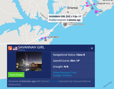
In general, the information broadcast is your MMSI (Maritime Mobile Service Identity) number, vessel name, length, speed, heading and location. This is helpful if you need to hail someone maybe to pass or for assistance so you know who you're talking to. On many systems you can tag “buddy boats” so when you travel in a group it's easy to identify your friends as well as keeping up with all transmitting vessels around you. Important information includes knowing what is around you and how the interaction between you and someone else could impact either vessel. If you have a transceiver, they can see and avoid you as well. It uses your speed plus direction and other vessels speed plus direction to automatically calculate if a collision is possible and provide a warning including closest point of approach (CPA) and the time until the CPA (TCPA). This is invaluable in low visibility or crowded waters. This does not preclude the most important “rule of the road” which is to maintain proper lookout at all times. While it is an excellent addition to safe boating there are still large numbers of vessels not broadcasting. I encourage you to join the ranks that are.
I hope I have provided enough information to get you thinking and do some research on your own to find out what you have, how it benefits you, and if any upgrades are desired. I believe the more knowledge we have the greater joy and safety for all of us that share our waters. FYI, there is a link to local Marine Traffic (Click link here) below “water level” on the right side of TownDock.net. Check it out!
Fair Winds
Wade Ellison/Amy Clifton
sv/Anticipation Too
|

